I have had some experiences with my B&G Zeus (T7) lately, which make me a little worried and give me some doubts about the reliability of the device. The first thing that comes to mind is that on our Atlantic crossing I had to do without most of the chart plotter functionality because B&G provided a faulty firmware update. With the GPS time change (Roll Over) this led to the fact that the built-in GPS did not determine a position (“No Fix”) any more. In theory, B&G’s internal GPS should not have been affected by this change, because I understand that Zeus does not use a date but only UTC to determine its position. Nevertheless, there have been problems with my firmware version (Zeus_Touch-2.0-46.1.139-28533-r2-Standard-4.upd). B&G reacted relatively quickly in this case and provided a new firmware (Zeus_Touch-2.0-46.1.139-28533-r4-Standard-4.upd) update with a fix. But this didn’t help me much in the middle of the Atlantic, because I couldn’t download it. (Update: Actually it fixed the issue later, when I arrived in the Caribbean, got Internet access and downloaded the firmware).
Using an alternative position source in the NMEA2000 network was also difficult because the B&G Zeus plotter kept losing the position provided by the other device. Even the prepared redundency for position data within the NMEA2000 network didn’t work in my case to overcome the issue. This was quite annoying.
Nevertheless, I am even more irritated that the B&G Zeus apparently does not display AIS information available in the NMEA2000 network. Here are a few examples:
- Apparently not all ships of B&G Zeus are displayed. Especially class B CS (“Carrier Sense”) transmitters are missing. I noticed this because I have two display devices on my AIS receiver (Watcheye B). On one hand I have the B&G Zeus and on the other hand I have a laptop with OpenCPN. On the laptop with OpenCPN I discovered vehicles that are not displayed on the B&G Zeus plotter. After some puzzling and analysis I got the impression that it is a systematic error and certain information is simply not displayed. In the list of AIS targets, these vehicles are present, but not on the map view. However, this is probably the most common view – for me it is the view that I use when I’m sailing.
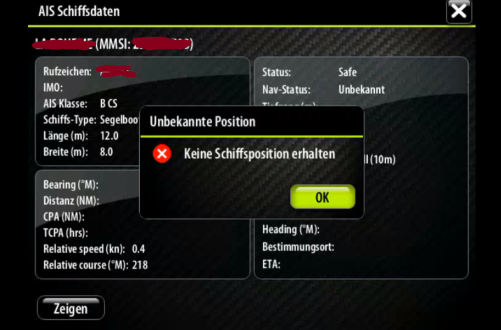
Figure 1: The B&G Zeus misses the position of the vessel
. - There is is similar issue with rescue vehicles (SAR). B&G Zeus misses some information completely, e.g. when rescue planes are in operation. If I am involved in a rescue operation, I would find this information very important. (This applies even the more if I need help urgently).
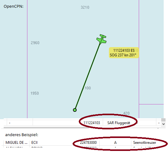
Figure 2: SAR vessels in OpenCPN
. - Even if the AIS targets are displayed, the information content of the B&G Zeus plotter can be optimized. E.g. some fishermen mark their nets with AIS transmitters. Related AIS transmitters can be recognized by their names (e.g. Harmony 11.1, Harmony 11.2 …). I think it is advisable not to sail between these AIS transmitters. Possibly thereis a net out there or you distub the fishing operations. Hence, it is helpful if this information is displayed. Unfortunately, B&G Zeus only displays a number for these transmitters (MMSI) and not the name which provides context information. (Please do not confuse this with “not yet” fully received AIS data, which looks similar.) If there are several fishermen on the way, it is very difficult (or impossible) to see where there is a gap. However, with the information it is not difficult to determine the areas of the different fishermen, their equipment and navigate between them.
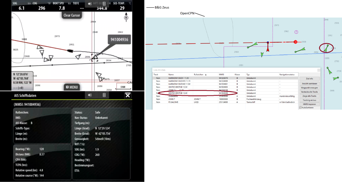
Figure 3: Differnt visualisation in B&G and OpenCPN
A last point of criticism is not an error, but an inherent problem of small displays or low resolution (as the T7 has). This makes the trip planning relatively annoying. At least if the Törm should go further than to the next anchor bay. If you select a route, then you have to “zoom out” so far that you can hardly see any details. I.e. you don’t see any information about the navigability (VTG, closed areas etc.). Therefore I plan longer routes mostly with the Navionics app on a tablet or online with the laptop. Unfortunately it is very complicated to transfer the waypoints to the B&G Zeus plotter. Maybe you could extend the GoFree-Wifi accordingly and provide a corresponding function?
P.S. This is not supposed beeing a “nag list” only – even if I wanted to write down my frustration. I have also sent this list to B&G (Navico) so that these bugs can be fixed. At least with the GPS problem the manufacturer has solved it relatively quickly. If I get an answer, I will update or add the anster to this article accordingly. Please let me know or leave a comment if you have ideas how to overcome the issues or if you have similar experiances with your device.
[Update 13.5.: I got some answers from the Navico support in the meantime. Regarding the problems with the incorrect display of AIS objects, this answer was unfortunately not very helpful. In principle it was pointed out that no function-enhancing updates are to be expected for my (only a few years old) device. It was suggested that I should buy a newer device or a “Class A” AIS because my application is almost “professional”. I think that a missing display of ships is a bug (and not a functional enhancement) and it’s a pity that the “planned obsolescence” seems to be part of their business model. My preliminary conclusion: With the free OpenCPN and an inexpensive tablet, you are possibly better equipped for future enhancements].
Additional information / references:
https://www.heise.de/autos/artikel/Navi-Update-wegen-GPS-Zeitumstellung-am-6-April-4364693.html
https://ww2.bandg.com/downloads/zeus-touch-software-update/
https://www.navcen.uscg.gov/pdf/AIS_A_vs_AIS_B_SO_CS.pdf
http://www.allaboutais.com/index.php/en/aisbasics1/ais-standards
